

Map geek, Star Trek nerd, voter. I grew up in southern Lancaster County, PA and moved to Philadelphia in 2006. I am a longtime activist for civil, economic, health, and environmental justice. I believe we can make the world better through political and civic engagement, sustainability, and using technology for good. This is what drew me to geospatial science in the first place.
I enjoy baseball, bikes, bad puns, fishing, data, and maps. The greatest television show ever produced is Star Trek: Deep Space Nine, and you'll never change my mind.
Geography is about understanding ourselves and our relation to the universe around us. GIS analysis and cartographic design are powerful tools to help us understand our role and impact on the planet and convey that information--and the importance of that information--to others. Geospatial analysis is the most comprehensive tool we have to build a better future.
I am currently a Philadelphia-based GIS and data analysis specialist with a background in cartographic modeling, spatial data analysis, web-based systems, remote sensing, and city planning. I hold a Master's degree in Urban Spatial Analytics from the University of Pennsylvania and a B.A. in Geography and Urban Studies from Temple University.
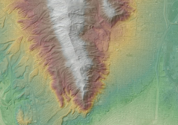
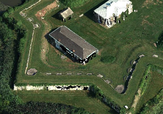
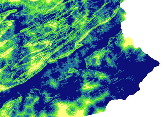
My professional experience has brought me through all levels of cartography and analysis from start to finish. I worked as a field surveyor for the Philadelphia City Planning Commission, collecting data on land use for the Philadelphia2035 Comprehensive Plan. On the GIS technician side, I digitized parcels and respective land uses for the plan. I have worked as an aerial sensor operator, controlling digital and film cameras from airplanes (learning some serious hardware skills) and learning what makes good data good and how to avoid bad data and fix it when necessary. From here, I moved to the production end, learning from highly experienced photogrammetrists. Here, my roles included orthophoto production, photogrammetric terrain modeling, radiometric balancing and enhancement, accuracy assessment, project management and application development. I have experience doing high-level statistical analyses on a variety of subjects, including suitability, spatial-temporal epidemiology, hydrological modeling, terrain analysis, crime prediction, and economic development indicators. I am grateful for the wide range of experiences I've had so far, and look forward to continuing my learning.
I am currently proud to be a GIS Analyst at the Philadelphia Office of the District Attorney. I am here to help build a strong data analysis and GIS backbone so we can leverage geospatial technology to further the mission of criminal justice reform.
My professional interests include remote sensing and survey, geodesy, geophysics, environmental science and modeling, planetary science, land use planning, data visualization and GIS application programming and development.
WESLEY CARLIN WEAVER
wesweaver1@gmail.com
www.wesmapping.com • @WesWeaver
EDUCATION
University of Pennsylvania, Philadelphia, Pennsylvania
Master of Urban Spatial Analytics, May 2013
• Recipient of PennIUR Masters Capstone Poster Award
Temple University, Philadelphia, Pennsylvania
Bachelor of Arts, Geography and Urban Studies, May 2010
• Recipient of Carolyn Adams Award in Geography and Urban Studies
EXPERIENCE
Philadelphia Office of the District Attorney, Philadelphia, Pennsylvania
Assistant Supervisor of Analytics, January 2021 - Present
• Supervise data analysts, data analysis, tools, and products in the District Attorney's Transparency Analytics (DATA) Lab.
• Promote a "data culture" in the District Attorney's Office and with our government and community partners.
• Help policymakers think through difficult decisions and test their hypotheses.
• Open more and more data to the public.
Senior GIS & Data Analyst, November 2019 – January 2021
• Using data to inform, create, and evaluate policy decisions.
• Opening criminal justice system data to the public for the first time ever.
• Building tools to help engage government, activists, and the community.
• Provide analytical support to the Election Task Force to protect everyone's right to vote.
GIS Analyst, February 2019 – November 2019
• Helping to build a mapping and analytics department to support the District Attorney's Office and pursue the mission of criminal justice reform in Philadelphia.
Keystone Aerial Surveys, Inc., Philadelphia, Pennsylvania
Geospatial Analyst & Production Manager, August 2013 – February 2019
• Promoted from positions as Aerial Sensor Operator and Geospatial Production Technician
• Lead photogrammetrist and manager of Geospatial Products Department
• Create geospatial products including orthoimagery, terrain datasets and high accuracy 3D models through photogrammetric methods and GIS.
• Research and develop new technology and methodology for sensors, systems, products and platforms.
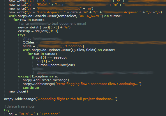
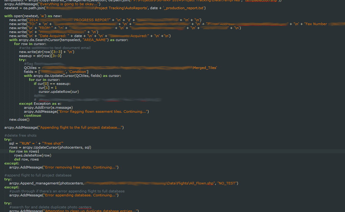
• Develop scripts and programs to augment production and project management, introducing high automation to the workflow.
• Correspond and meet with clients.
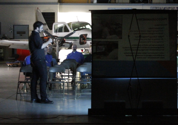
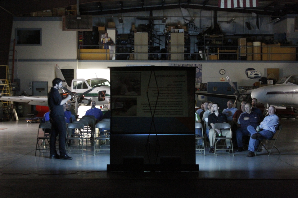
• Present products, methods and technology to clients, students and corporate partners.
• Manage and conduct Keystone's 3D Printing pilot program.
• Process and balance imagery, perform QA/QC and ensure high quality data.
• Operate digital and film aerial cameras in survey aircraft.
Philadelphia City Planning Commission, Philadelphia, Pennsylvania
GIS Intern, February 2013 – May 2013
• Maintained GIS data on land use for the Philadelphia2035 comprehensive plan.
• Updated land use geodatabase with new field data, editing data to match existing topology.
• Conducted field surveys of land use in planning districts to verify and update PCPC records.
• Developed scripts and models to automate project management.
Goldberg, Miller & Rubin, P.C., Philadelphia, Pennsylvania
File Clerk, August 2007 – August 2012
• Maintained file system in-house and at external facilities and managed electronic data storage.
United States Student Association, Washington, Distict of Columbia
GrassRoots Organizing Weekend Trainer, January 2009 – May 2010
• Train college students and community group members on organizational development and strategic planning.
VOLUNTEER EXPERIENCE
Philadelphia Jobs with Justice, Philadelphia, Pennsylvania
Organizer, August 2006 – July 2011
• Volunteer community grassroots organizer for five years over numerous projects and campaigns.
Skills and Interests: Primary research interests include remote sensing science and technology, geospatial science and spatial data analysis. Extensive experience with GIS environments and photogrammetry. Experience in spatial data analysis, statistics and analysis software. Comfortable with several computer languages. I love baseball, music, stringed instruments and science fiction.
Journal Publications:
• Day, D., Weaver, W., Wilsing, L. (2016). Accuracy of UAS Photogrammetry: A Comparative Evaluation. Photogrammetric Engineering & Remote Sensing, Volume 82(12), pp. 909-914.
Conference Publications:
• Gur, O., Weaver, W., Zambrana, J., Fisher, D., Libbey, K., Hollander, M., Berman, M., Caplan, J. Developing a geospatially-informed approach to prosecution, community engagement, and criminal justice reform. American Society of Criminology 2019, San Francisco, 14 November.
• Passini, R., Weaver, W., Day, D. (2017) Accuracy analysis of DEMs generated from UAS imagery and large format digital cameras. Conference proceedings of the Imaging & Geospatial Technology Forum 2017: ASPRS Annual Conference, Baltimore, 12 March.
• Passini, R., Weaver, W., Day, D. (2017) A study on the accuracy of DEMs generated from UAS imagery as compared to latest generation LiDAR. Proceedings of the International LiDAR Mapping Forum (ILMF) 2017, Denver, 2 February.
• Passini, R., Jacobsen, K., Weaver, W., Day, D. (2016). A study on oblique camera systems and the stability of their parameters. Proceedings of the Imaging & Geospatial Technology Forum 2016: ASPRS Annual Conference, Fort Worth, 11-15 April.
• Passini, R., Day, D., Weaver, W. (2015). An accuracy analysis of large resolution images captured with the Nikon D810 digital camera system. Proceedings of the Imaging & Geospatial Technology Forum 2015: ASPRS Annual Conference, Tampa, 4-8 May. (Download here)
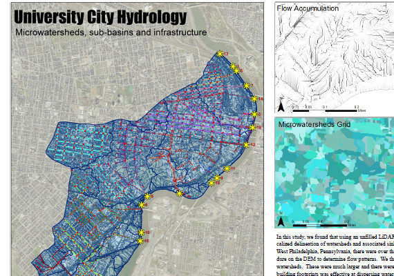
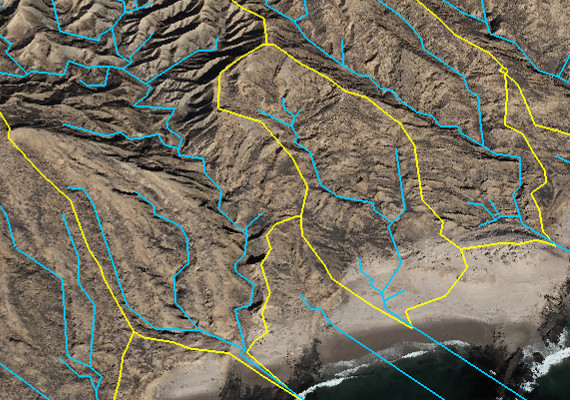
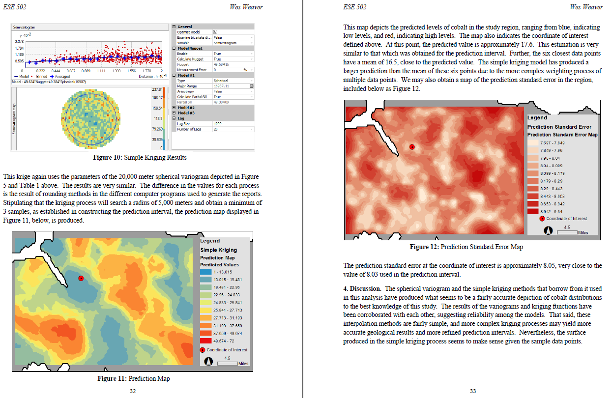
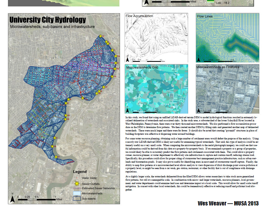
• Weaver, W. (2013) Microwatershed Modeling with LIDAR and Interactive GIS Methods. ESRI International User Conference 2013, Poster Display, San Diego, July.
Press:
• McCrone, Brian X. "Liberals, Progressives Beat Up Philadelphia's Party Machine on Election Day." NBC Philadelphia, 18 May 2017.
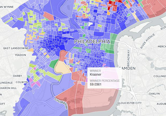
• Marin, Max. "See how every neighborhood voted in the Philly DA race." Philadelphia Weekly, 9 Nov 2017.
Presentations & Invited Talks:
• Conference on Law Enforcement & Public Health, March 2021, Philadelphia, PA – An inter-agency public health and safety approach to analyzing shootings and gun crimes in a major US city during COVID-19: What the data shows, panelist
• Virginia Crime Analysis Network Webinar, January 2021 – The Philadelphia District Attorney's Office Transparency Analytics (DATA) Lab: Creating a 21st Century, Researchable Prosecutor's Office.
• Southeastern Pennsylvania GIS User Group Inaugural Meeting, March 2017, King of Prussia, PA – Drones for Inspection and Mapping: Current and Future Usage
• Rowan College at Burlington County GIS Day, November 2016, Mount Laurel, NJ – Digital Photogrammetry & Aerial LiDAR and panelist
• Imaging & Geospatial Technology Forum - ASPRS Annual Conference, April 2016, Fort Worth, TX – Paper Presentation: A study on oblique camera systems and the stability of their parameters
• ESRI International User Conference 3D Mapping Forum, July 2015, San Diego, CA – Fusion of Airborne and Ground Imagery Derived Point Clouds in Preparation for 3D Printing
• North Atlantic ASPRS Technical Workshop, October 2014, Philadelphia, PA – Imagery-derived Point Clouds
• NJ Geospatial Forum, March 2014, Trenton, NJ – Innovations in Geospatial Image based Data Acquisition
• UPenn MUSA Lunch Series, February 2014, Philadelphia, PA – Geospatial Data Acquisition and Photogrammetry
Continuing Education & Self Learning:
• GPS: An Introduction to Satellite Navigation, Stanford University – Coursera – Statement of Accomplishment with Distinction, December 2014
• Geospatial Intelligence and the Geospatial Revolution, Pennsylvania State University - Coursera - Statement of Accomplishment with Distinction, February 2015
